Nature
The Bay of Mont-Saint-Michel: Seals, Salt-Meadow Sheep, Birds and Tombelaine
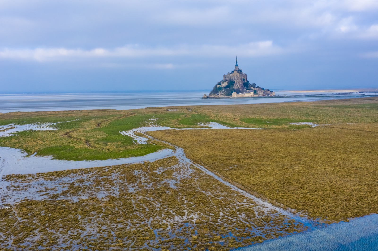
Most visitors see the bay of Mont-Saint-Michel as the setting for the abbey: a plain of sand at low tide, a sheet of water at the biggest high tides. It is also a working ecosystem that the state’s environment agency for Normandy, the DREAL, ranks among natural areas of international value. The bay is a depression of about 500 km², 250 km² of it sands and salt meadows. The Ramsar Convention counts 100,000 or more waterbirds wintering there. In 2025 aerial counts found up to 132 harbour seals on its sandbanks, and sheep graze the salt meadows around the Mont, their lamb protected by its own designation of origin. Three kilometres to the north stands Tombelaine, a granite islet that has been a bird reserve since 1985.
This article is about the bay as a living place: what lives where, when to see it and how it is protected. The tides themselves, and the guided walks across the sands, have their own tides and bay walks guide, which this page links to rather than repeats.
The short answer
- Size: a depression of about 500 km², with 250 km² of sands and salt meadows; the intertidal zone covers more than 240 km².
- Salt meadows: about 4,000 hectares around the bay, among the largest in Europe according to the Ramsar Convention.
- Seals: harbour seals breed in the bay; in 2025 the counts ranged from 24 to 132. Grey seals, between none and 12, visit in summer but do not breed here.
- Birds: 100,000 or more waterbirds winter in the bay, including over 1% of the populations of red knot and dunlin.
- Tombelaine: State property, a bird reserve since 1985 and a historic monument since 1936, reached only with a guide.
- Protection: UNESCO World Heritage since 1979, a Ramsar wetland since 1994, two Natura 2000 sites of about 50,000 ha and a classified site since 1987.
Sand, mud and salt marsh: how the bay is built
Three main rivers, the Sée, the Sélune and the Couesnon, flow into the bay, and the tide does the rest. The Ramsar Convention describes the intertidal zone, more than 240 km², as a mosaic of mudflats, hermella reefs and salt marshes. The best known of those reefs, the Hermelles bank, lies five kilometres off the coast on the Breton side; it is built by marine worms, and the article on where Mont-Saint-Michel is describes it.
The ground itself keeps moving. Every year the sea deposits nearly a million cubic metres of marine sediment, the tangue, in the bay. That steady silting is the natural process the works around the Mont were designed to counter, and it shapes everything else here: the sandbanks the seals rest on, the meadows the sheep graze and the channels the birds feed along.
It is also the base of the food chain. The DREAL explains that the vast sandy foreshore uncovered at low tide produces the invertebrates that feed the bay’s fish and birds. A bare-looking stretch of sand is, in other words, a larder.
The salt meadows, or herbus
At the top of the shore, where only the biggest tides reach, the sand gives way to grass and low plants. These are the salt meadows, called prés salés or herbus locally, and also schorres. The Mont’s public establishment puts them at about 4,000 hectares of salt-tolerant vegetation around the bay. The Ramsar Convention describes them as among the largest salt marshes in Europe, home to 22 protected plant species, and the DREAL says that at the mouths of the Sée, Sélune and Couesnon they cover some of the largest such areas in France.
The plants are specialists. INAO, the national body for designations of origin, names three of them: puccinellia, sea arrowgrass and sea purslane, all adapted to salty soil and to being covered by the sea at big tides. On the Breton side of the bay, the Maison de la Baie runs a walk among the salt meadows’ edible plants, salicornia and sea purslane among them.
The meadows are not purely a blessing. The DREAL notes that the silting of the bay and the spread of the herbus around the Mont threatened its maritime setting, one reason for the dam and the bridge-walkway that replaced the old causeway. The history article tells that story. The easiest way to cross the meadows yourself is the signposted 12 km cycle link from the Pontaubault bridge to Avranches station.
The sheep of the salt meadows
Sheep graze the herbus all around the bay. The abbey says the salt-meadow sheep can be seen from its West Terrace.
Their lamb carries a protected designation of origin, AOP Prés-salés du Mont-Saint-Michel. A notice of the European Commission’s registration of the name appeared in the JORF, the French government’s gazette, on 1 July 2014, and INAO’s product sheet sets out what makes it:
- Grazing: the lambs graze the salt marshes for at least half of their rearing period.
- Diet: puccinellia, sea arrowgrass and sea purslane are very palatable and make up most of what the lambs eat on the marshes.
- Effort: forage on the salt marshes is fairly sparse, so the animals walk long distances to feed.
- Place: the maritime grazing zone is the salt marshes of the bay and the havres, the estuaries, of the Cotentin. Its area changes with the movement of sediment.
- Area: the wider production area runs around the Normandy–Brittany gulf, on the coasts of the Manche and Ille-et-Vilaine, and includes about 370 communes.
INAO describes the meat as deep rosy in colour, marbled and juicy. To taste it on the Mont, the article on La Mère Poulard and the Mont’s food covers the omelette and the other specialities.
Seals: the bay’s harbour seal colony
Harbour seals breed in the bay. The DREAL lists the harbour seal among the bay’s emblematic species, tied to sheltered coasts dotted with sandbanks, which is exactly what the bay offers at low tide.
The Mont’s public establishment has monitored the colony since 2012, as part of the follow-up of the works that restored the Mont’s maritime character. The monitoring is funded by the French Biodiversity Office. The seals are counted from a microlight 10 times a year, along the channels between the Mont and the open sea, and individual animals are recognised from photographs. The 2025 report gives a clear picture:
- Harbour seals: from 24 in March to 132 in September.
- Grey seals: from none in March and October to 12 in July.
- Births: 23 harbour seal pups, born between 1 July and early August. Five stranded and were cared for alive.
- Grey seals do not breed in the bay. They come outside their breeding season, for a summer rest.
- Individuals identified: 133, of which 15 grey seals and 118 harbour seals. Some move between the bay and other sites such as the Sienne, the Arguenon and Chausey.
Summer is the busy season for both species. The harbour seals use their resting places on the sand, the haul-outs, more in summer, for pupping, nursing, breeding and moulting. At low tide the haul-outs are in the heart of the bay, along the channels of the Couesnon, the Sée and the Sélune; at high water they move closer to the coast.
The seals have company. The Ramsar summary lists bottlenose dolphins and harbour porpoises among the marine mammals that visit, and the abbey describes seals and dolphins as regulars of the bay.
Watching seals without disturbing them
The haul-outs are far out on the sands, among channels and quicksand, so the rule that applies to the whole bay applies doubly here: it is extremely dangerous to venture out alone, even close to the Mont. There are better ways:
- From the Mont. The abbey’s West Terrace and the ramparts look out over the bay, and the public establishment’s 2025 programme included a 2-hour birdwatching walk that climbs to the ramparts to watch the bay’s birds, and perhaps seals.
- With a naturalist. The Maison de la Baie’s 5- to 6-hour wildlife hike goes into the wild part of the bay with telescopes to watch waterbirds, raptors and perhaps the seal colony.
- With binoculars and distance. The public establishment’s own report notes that its photographs were taken with optics from far enough away to avoid any disturbance. That is the standard to copy.
The public establishment says it works with the bodies responsible for biodiversity to protect the seals.
Birds: a winter crowd of 100,000
For birds, the bay matters on a continental scale. The DREAL describes it as a site of international importance for migratory birds, on the main western European migration route. The Ramsar summary is more specific:
- Winter: 100,000 or more waterbirds winter in the bay, including over 1% of the populations of red knot and dunlin.
- Passage: the aquatic warbler uses the bay as a migratory stopover, and several dozen are monitored each year.
- Moult: the Balearic shearwater is present while it moults.
The mechanics are simple. The falling tide uncovers mudflats full of invertebrates, and wading birds follow the water out and back. The DREAL adds that the wetlands around the bay, the peripheral marshes, serve as resting and feeding areas.
Two guided ways to see them:
- The Maison de la Baie’s bird walk, 2 hours, uses telescopes to watch the birds and their habits up close, on the Breton side of the bay. Its walks are limited to about 25 people.
- The public establishment’s nature programme, which in 2025 included the birdwatching walk to the ramparts, meeting at the Porte du Roy.
Tombelaine: the bird islet
Tombelaine is the smaller granite rock you see 3 km north of the Mont. Découverte de la Baie, one of the walking companies, describes it as nearly 40 m high and 3.8 ha in area, where the estuaries of the Sée, Sélune and Couesnon meet. It lies in the commune of Genêts.
Its status is clear on paper. The Ministry of Culture’s heritage register records that the islet belongs to the State’s private domain and has been a bird reserve since 1985, and that it was classified as a historic monument by an order of 9 October 1936. During the Hundred Years’ War it was an English stronghold facing the Mont, and it still holds ruins from that period.
The abbey says many birds come to nest there in spring, so treat it as the reserve it is:
- Only with a guide. Tombelaine can be reached on foot only in the company of a guide.
- The walks. From the Mont, Découverte de la Baie’s walk covers 7 km in about 3.5 hours; from the Bec d’Andaine, 8 km in about 4 hours, crossing the small river Lerre to the foot of the rock, where the guide tells its history and legends. The tides guide compares the operators and prices.
- The rules. Because the islet is a reserve, follow your guide’s instructions on where you may go.
Fish, eels and the mussel beds
The water is as busy as the sand. The DREAL notes that Atlantic salmon pass through the bay to spawn in rivers such as the Sée. The Ramsar summary adds the European eel and the undulate ray (Raja undulata). It also reported a plan, then under way, to restore the ecological continuity of the Sélune by levelling two hydroelectric dams. That work is now done: the Seine-Normandy water agency says the Vezins dam was removed in 2020, demolition of La Roche-qui-Boit began on 20 June 2022, and the Sélune now flows freely.
People farm the bay too, and the DREAL counts shellfish farming, fishing and nature tourism among the activities that depend on the quality of its water. The best-known product is the mussel. Moules de bouchot de la baie du Mont-Saint-Michel were the first shellfish to receive an appellation. They grow on posts called bouchots, set in the foreshore and uncovered at low tide, and INAO credits the bay’s abundant plankton for their plumpness. They are seasonal: the season generally opens in July and runs to February, depending on the harvest. On land, 8 communes belong to the production area, where the mussels are sorted and packed. One of the main mussel-farming areas lies between Cancale and Le Vivier-sur-Mer, on the Breton shore, and Cancale itself is known for its oysters.
Quicksand and a shifting bay
Everything in the bay moves. Découverte de la Baie describes it as a shifting environment of sandbanks, channels and mudflats, where the water can rise quickly in places. Even the salt meadows change shape: INAO notes that the area of the grazing marshes changes with the movement of sediment.
Quicksand is part of that. Découverte de la Baie explains that quicksand is not dangerous in itself, since you cannot drown in it, but that it becomes a risk if the sand sets and you do not know how to get free. On all its outings the guide explains and demonstrates quicksand, and walkers can take part. Mud is the other trap: boots stick in it, which is why walkers go barefoot or in neoprene. The tides guide explains why these dangers, together with the incoming tide, mean you should only ever walk the bay with a certified guide.
How the bay is protected
The bay carries a stack of protections, and the public establishment lists the main ones:
- UNESCO World Heritage. Mont-Saint-Michel and its Bay were inscribed in 1979.
- Ramsar. The bay is Ramsar site no. 709, covering 47,800 ha, designated on 14 November 1994.
- Natura 2000. Two sites, mostly marine, under the European Habitats and Birds directives, cover about 50,000 ha.
- A classified site. The bay’s landscapes were protected as a classified site in 1987.
- Bird and wildlife inventories. The bay is also a ZICO, an important bird area, and is covered by several ZNIEFF inventories of natural interest.
- Tombelaine. A bird reserve since 1985 and a historic monument since 1936.
The bay also had an Opération Grand Site, the state’s programme for heavily visited landscapes, which the DREAL says ran until 2007. Even the food is protected: both the salt-meadow lamb and the bouchot mussels carry an AOP, which ties them to the bay’s own meadows and foreshore.
When to go for wildlife
- Winter: the wintering waterbirds, 100,000 or more in a season. Dress for the wind; the weather article has the numbers.
- Spring: nesting season on Tombelaine.
- July to early August: harbour seal pups, born in 2025 between 1 July and early August.
- Summer: grey seals rest in the bay; in 2025 the count peaked at 12 in July.
- September: the highest harbour seal count of 2025, 132.
- July to February: the AOP mussel season.
The West Terrace of the abbey is the easiest place to look out for the sheep; the abbey guide covers tickets and hours.
Seeing the bay with a guide
A guided walk is the only safe way onto the sands, and the guides cover nature as well as history. Découverte de la Baie says its guides talk about the tides, quicksand, the bay’s history, pilgrimages, and its fauna and flora. For wildlife in particular, the Maison de la Baie runs nature walks on the Breton side, and the public establishment runs its own seasonal programme around the Mont.
If you come by car, the car parks and the shuttle are on the mainland; dogs are allowed in the bay on a lead, but on the shuttles only if carried in a suitable bag or basket. The getting there guide has the details.
Frequently asked questions
Are there seals at Mont-Saint-Michel?
Yes. Harbour seals live and breed in the bay; in 2025 the public establishment’s counts ranged from 24 in March to 132 in September, with 23 pups born between 1 July and early August. Grey seals visit in summer, up to 12 in July 2025, but do not breed here.
Can you visit Tombelaine?
Only with a guide. Tombelaine is State property, a bird reserve since 1985 and a historic monument since 1936, and many birds nest there in spring. Guided walks from the Mont cover about 7 km, and from the Bec d’Andaine about 8 km.
What are the salt meadows at Mont-Saint-Michel?
Grassy marshes at the top of the shore, covered only by the biggest tides. They cover about 4,000 hectares around the bay and are among the largest salt marshes in Europe, with 22 protected plant species.
Why do sheep graze around Mont-Saint-Michel?
The salt meadows are their pasture. Lambs sold as AOP Prés-salés du Mont-Saint-Michel graze the salt marshes for at least half of their rearing period, eating plants such as puccinellia and sea purslane.
Is the bay of Mont-Saint-Michel protected?
Yes, many times over: UNESCO World Heritage since 1979, a Ramsar wetland since 1994, two Natura 2000 sites of about 50,000 ha and a classified site since 1987.
When is the best time to see birds in the bay?
Winter, when 100,000 or more waterbirds spend the season in the bay. Spring brings nesting birds to Tombelaine, and the bay lies on the main western European migration route.