Places
Where Is Mont-Saint-Michel? Normandy, Brittany and the Bay Around It
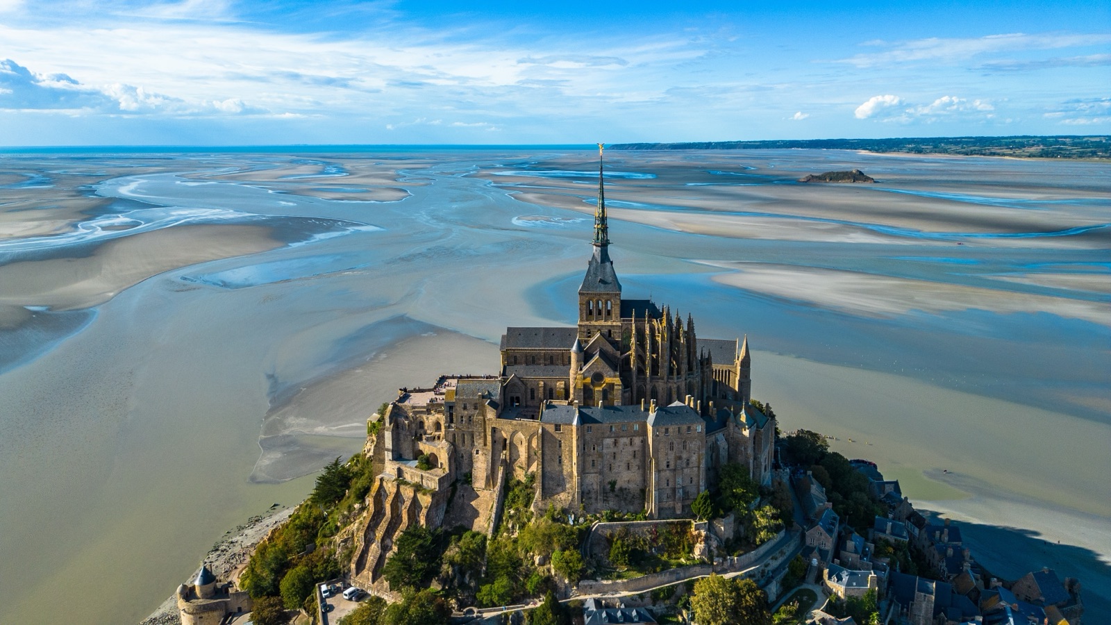
Mont-Saint-Michel is in north-west France, in Normandy. Administratively it is a commune of the Manche department, in the arrondissement of Avranches and the canton of Pontorson, according to INSEE, the French statistics office. It stands on a granite islet in the bay that carries its name, on the English Channel, right at the point where Normandy meets Brittany: UNESCO describes it as standing at the limit between the two.
That position explains most of what people ask about its location. The Mont is Norman, but only just: the small river Couesnon reaches the sea beside it, and its final stretch is the old border between the duchies of Normandy and Brittany. The nearest railway station is at Pontorson, 9 km away; the nearest airports are Dinard (70 km) and Rennes (75 km); and Paris is 337 km by road. Below we set out the border question, the distances that matter, and the towns, islets and viewpoints around the bay, on both the Norman and the Breton shore.
The short answer
- Country and region: France, Normandy.
- Department and district: Manche; arrondissement of Avranches; canton of Pontorson.
- Border: on the Normandy side of the Couesnon, the river that historically separated Normandy from Brittany.
- Canton town and nearest station: Pontorson, 9 km.
- Nearest airports: Dinard 70 km, Rennes 75 km, Caen-Carpiquet 130 km.
- By road: 337 km from Paris, 188 km from Nantes.
- Nearest ferry ports for the UK: Saint-Malo, on the Breton side of the bay.
Is Mont-Saint-Michel in Normandy or Brittany?
Normandy. INSEE places the commune in the Normandy region and the Manche department, and that is not in doubt today. The question persists for a good reason: the Mont sits right on the edge of Brittany, and the historical border here was a river that would not keep still.
UNESCO’s description of the World Heritage site captures the position neatly. It describes a rocky islet amid vast sandbanks exposed to powerful tides, at the limit between Normandy and Brittany. The bay is shared between the two regions too: UNESCO notes that the site is governed through the Conference of the Bay, chaired by the Prefect of the Normandy region together with the presidents of the Normandy and Brittany regions.
The river that decides it
The border question is really a question about one river, the Couesnon. Its final stretch forms the border between the historical duchies of Normandy and Brittany. For centuries it did not keep to one course: it shifted between two beds, to the north and to the south of the Mont, before settling on the southern one. With the river’s mouth on the Breton side of the rock, the Mont ended up in Normandy.
The Couesnon rises in the Mayenne department, runs north through Ille-et-Vilaine past Fougères, and enters Manche at Pontorson before reaching the bay. Crossing it has long been hazardous: the Bayeux Tapestry shows Harold Godwinson and his men crossing the Couesnon, and the tourist office points out that scenes 16 and 17 of the tapestry show knights caught in quicksand in front of Mont-Saint-Michel.
That gave rise to a well-known saying: Le Couesnon en sa folie mit le Mont en Normandie, “the Couesnon in its madness put the Mont in Normandy”. It treats the Mont’s Norman status as the work of a wandering river rather than of any treaty or decision.
The modern administrative boundary between the two regions does not follow the river’s present course: it runs to the west of the Mont. So if you drive or cycle in from Brittany, you cross into Normandy before you reach the Couesnon.
The Couesnon today
The river is also the key to the Mont’s recent engineering. A dam on the Couesnon, in service since 2009, holds back water at high tide and releases it on the ebb to flush sand away from the rock. It is part of the works that replaced the 1879 road causeway with a bridge-walkway in 2014 and made the Mont an island again. The dam stands on the approach road, with a viewing platform, and upstream the Moidrey cove, a natural area along the Couesnon estuary 7 km from the Mont, has an interpretation trail with the Mont as a backdrop.
Distances that matter
These are the distances given by the bodies that run the site and by the national cycling network. Note that the visitor car park and the shuttle terminus are on the mainland, near La Caserne, a small commercial area between the car park and the dam with hotels and restaurants; a shuttle carries visitors from there to the foot of the rock. Road and rail times are in our guide to getting to Mont-Saint-Michel.
| From | Distance | Source and note |
|---|---|---|
| Visitor car park | 2.5 km | On the mainland; shuttle or walk to the Mont |
| Tombelaine islet | 3 km | Across the sands, to the north |
| Moidrey cove | 7 km | Along the Couesnon estuary |
| Pontorson | 9 km | Nearest railway station |
| Dinard airport | 70 km | Private flights, per the tourist office |
| Rennes airport | 75 km | Domestic and connecting flights |
| Caen-Carpiquet airport | 130 km | Has direct flights to London |
| Nantes | 188 km | By road, via the A84 |
| Paris | 337 km | By road, via the A13 and A84 |
| Saint-Malo | 68 km | By the coastal cycle route, not by road |
What you can see from the top
The best map of the region is the view from the abbey. From the west terrace, the abbey’s managers say, the panorama runs from the Rock of Cancale in the west, across Brittany, to the cliffs of Normandy in the east. Two granite massifs stand out: Mont-Dol, inland to the west, and the islet of Tombelaine to the north. Offshore you can make out the Chausey Islands, where the granite used to build the abbey was quarried.
It works the other way round as well. UNESCO’s buffer zone around the site, proposed in 2018, takes in almost 130 communes; its boundary was drawn from a landscape study of where the Mont, the main panoramas and the Montjoies, the viewpoints on the old approaches, are all visible. UNESCO warns that the Mont’s silhouette, visible from so far away, is vulnerable to anything built that alters the views to and from it.
The bay itself
The Mont is only the centre of a much larger natural site. The World Heritage property covers 6,560 hectares, with a buffer zone of 191,858 hectares, and the bay has been protected under the Ramsar Convention on wetlands since 1994.
Its defining feature is the tide. The tourist office says the bay has the highest tides in continental Europe, with a difference of up to 15 metres between low and high water; at big tides the sea withdraws 15 kilometres from the coast and comes back very quickly. That is why walking out on the sands without a guide is extremely dangerous, even close to the Mont. Three rivers flow into the bay around the Mont, the Sée, the Sélune and the Couesnon, and on the rising tide a tidal bore runs up all three. Five kilometres off the coast on the Breton side of the bay lies the Hermelles reef, built by marine worms and described by the Maison de la Baie as the largest animal construction in Europe, covering more than 100 hectares.
The long-distance GR 34 footpath follows the whole bay, from Cancale in Brittany to Granville in Normandy, so on foot you can trace the entire curve of the coast. Our guide to tides and bay walks covers tide times and the guided walks across the sands.
Around the bay: the Normandy side
Tombelaine
The smaller granite rock 3 km to the north of the Mont is Tombelaine. During the Hundred Years’ War it became an English stronghold facing the Mont, and it still holds ruins from that period. Today it is a bird reserve. Walking there alone across the sands is dangerous, but guided return walks from the Mont cover about 6 to 7 km in about 3 hours.
Genêts and the Bec d’Andaine
The classic crossing to the Mont on foot starts on the Normandy shore, at the Bec d’Andaine, 1.5 km from the village of Genêts, or, depending on the date, at Saint-Léonard near Vains. A guided return crossing covers 13 to 15 km and takes about 6 hours, passing close to Tombelaine when it starts from the Bec d’Andaine.
Avranches
Avranches, on the Normandy shore of the bay, has the deepest roots in the Mont’s story. Aubert, the bishop who founded the first sanctuary in 708 according to legend, was bishop of Avranches, and the Mont still belongs to the arrondissement of Avranches today. Its manuscripts ended up there too: the abbey says two hundred of its medieval manuscripts are now kept in Avranches.
The Scriptorial d’Avranches, the museum of the Mont-Saint-Michel manuscripts, shows them; Normandie Tourisme lists adult entry from €9. Keep the ticket: with it, the abbey ticket is reduced to €13 between 1 April and 30 September 2026, and to €11.50 from 1 October 2026. Cyclists can reach Avranches station by a signposted 12 km link from the Pontaubault bridge, across the salt meadows.
Pontorson and Beauvoir
Pontorson is the Mont’s railway station and its canton town, 9 km inland. The station is on the regional line between Granville and Saint-Malo, with on average 2 trains a day serving the Mont according to France Vélo Tourisme, and buses connect the station with the Mont. A greenway connects it with the Mont for walkers and cyclists, and from Beauvoir the Vélomaritime cycle route continues east on minor roads to the Sée estuary at Pontaubault and then by greenway to Ducey.
Granville and the Chausey Islands
At the northern end of the bay, Granville is the Normandy port for the Channel Islands, with Manche Iles Express sailings. The Chausey Islands, the archipelago you can see offshore from the abbey’s terrace, supplied the granite for the abbey. The GR 34 ends its circuit of the bay at Granville.
Around the bay: the Brittany side
Cherrueix and the polders
West of the Couesnon you are in Brittany. The coastal cycle route from Le Vivier-sur-Mer to the Mont passes the bay-side village of Cherrueix, with its windmills and St Anne’s Chapel, through marshes and polders reclaimed from the sea. It enters the Manche department beyond Cherrueix and crosses the Couesnon by a footbridge at Moidrey.
Le Vivier-sur-Mer
Le Vivier-sur-Mer is mussel country. Between Cancale and Le Vivier the cycle route passes one of the bay’s main mussel-farming areas, known for its AOP bouchot mussels, grown on posts. The Maison de la Baie, at the east port of Le Vivier and right beside the GR 34, runs nature walks on the Breton side of the bay. By the Vélomaritime route it is 29 km from Le Vivier to the Mont.
Mont-Dol and Dol-de-Bretagne
Inland from Le Vivier, about 10 km away, is Dol-de-Bretagne, a small historic town with a railway station. On the way stands Mont-Dol, the granite hill you see to the west from the abbey; France Vélo Tourisme describes its views over the marshes and the whole bay as exceptional.
Cancale
Cancale, on the Emerald Coast, is a fishing port renowned for its oysters, and the Rock of Cancale marks the western edge of the view from the abbey. The cycle stage from Cancale to Le Vivier-sur-Mer is 21 km.
Saint-Malo
Saint-Malo, the old corsair city, is the ferry port on the Breton side of the bay. Brittany Ferries sails there from Portsmouth, and Condor Ferries links it with Poole via Jersey or Guernsey. France Vélo Tourisme’s coastal ride from the Mont to Saint-Malo is 68 km along the Breton shore, made up of stages of 29 km to Le Vivier, 21 km to Cancale and 18 km on to Saint-Malo. By public transport, Keolis Armor runs one return coach trip from the Esplanade Saint-Vincent in Saint-Malo on the days it operates; check those days before you plan around it.
Exploring both shores
The bay makes a natural loop, and the places above fall into three easy groups. The cycle-route distances give a sense of scale; road distances and driving times will differ.
- The Breton shore, west to east. From Saint-Malo the coastal stages run 18 km to Cancale for its oysters, 21 km on to Le Vivier-sur-Mer for the mussel beds and the Maison de la Baie, and 29 km past the windmills of Cherrueix to the Mont, crossing into Normandy before the Couesnon. A detour of about 10 km inland from Le Vivier takes in Mont-Dol and Dol-de-Bretagne.
- The Norman shore. Avranches, with the Scriptorial and the abbey’s manuscripts; Genêts and the Bec d’Andaine, where guided crossings to the Mont begin; and Granville at the northern end, with boats to the Channel Islands. The GR 34 links them on foot.
- Around the Mont itself. The dam’s viewing platform on the approach road, the Moidrey cove 7 km up the Couesnon, and Tombelaine, 3 km out on the sands, which you should only visit with a guide.
Whichever shore you choose, plan around the tide: the sea comes and goes over a vast area, and the same stretch of sand can be a beach in the morning and open water in the afternoon. The tides and bay walks guide explains how to read the tide tables.
Arriving from further away
Several long-distance routes end at the Mont:
- From Paris, the Véloscénie cycle route ends at the Mont, and the road via the A13 and A84 is 337 km.
- From the D-Day beaches, the VéloWestNormandy cycle route runs to the Mont.
- From Caen, the Vélomaritime links the city with the Mont and continues west into Brittany.
- From the UK, Saint-Malo is the nearest ferry port and Caen-Carpiquet, 130 km away, has direct flights to London.
The Mont also sits on the old pilgrim network. Besides its own listing in 1979, it was later inscribed as part of the Routes of Santiago de Compostela in France, and guided crossings of the bay still follow the line of the medieval pilgrims’ approach across the sands.
For the practical routes, from tours and trains to the car parks and the Passeur shuttle, see our guide to getting to Mont-Saint-Michel. If you are wondering whether the Cornish island of the same saint is the same place, it is not: our comparison of St Michael’s Mount and Mont-Saint-Michel explains the link between them, and our article on Mont-Saint-Michel’s history tells the story of the rock itself.
Frequently asked questions
Is Mont-Saint-Michel in Normandy or Brittany?
Normandy. INSEE places the commune in the Normandy region and the Manche department. It lies just on the Norman side of the Couesnon, the river whose last stretch formed the historical border with Brittany, which is why the question comes up so often.
What is the nearest town to Mont-Saint-Michel?
Pontorson, 9 km inland, is the canton town and has the nearest railway station. The visitor car park is on the mainland, 2.5 km from the Mont, with a shuttle to the foot of the rock.
How far is Mont-Saint-Michel from Saint-Malo?
France Vélo Tourisme’s coastal cycle ride from the Mont to Saint-Malo is 68 km along the Breton shore, via Le Vivier-sur-Mer and Cancale. Saint-Malo is also the nearest ferry port for travellers from Portsmouth and Poole.
What is the nearest airport to Mont-Saint-Michel?
Dinard, 70 km away, but it handles private flights according to the tourist office. Rennes airport is 75 km away, and Caen-Carpiquet, 130 km away, has direct flights to London.
Which department is Mont-Saint-Michel in?
The Manche department of Normandy, whose prefecture is Saint-Lô, according to INSEE. Within Manche it belongs to the arrondissement of Avranches and the canton of Pontorson.
Is Mont-Saint-Michel an island?
Yes, a tidal one. Since the works completed in 2015 it is reached by a bridge-walkway, and at the biggest tides the sea covers the approach and the Mont becomes an island again for about an hour.